About West Seattle Link Extension
The West Seattle Link Extension will provide fast, reliable light rail connections to dense residential and job centers in the SODO, Delridge, and West Seattle neighborhoods. The West Seattle Link Extension is part of the regional transit system expansion approved by voters in November 2016.
West Seattle Link Extension
- Adds 4.1 miles of light rail service from SODO to West Seattle's Alaska Junction neighborhood.
- Includes four new stations from SODO to Alaska Junction.
- Start of service scheduled for 2032.
West Seattle Link Extension project timeline
2016 Voter Approval
- Alternatives development
- ST Board identifies preferred alternative
- Draft Environmental Impact Statement
- ST Board modifies the preferred alternative for West Seattle Link Extension
- ST staff conduct further studies
- Ongoing environmental review
- Final Environmental Impact Statement (2024)
- ST Board selects project to be built (2024)
- Federal Transit Administration issues Record of Decision (early 2025)*
*Depending on federal consultation
- Procure final design and construction contracts
- Obtain land use and construction permits
- Begin property acquisition / relocation
- Advance utility relocation / early work contracts
- Demolition and clearing where necessary to build and operate the light rail guideway
- Earth work such as stormwater systems, column footings, retaining walls and tunneling
- Guideway and station construction
- Ongoing conversations with anyone affected by construction
- Safety education
- Testing and preparations
2032 Start of Service
The West Seattle Link Extension (WSLE) is currently in the environmental review phase. After publishing the Draft Environmental Impact Statement (EIS) in 2022 and a 90-day comment period, the Federal Transit Administration and Sound Transit have published the Final EIS on Sept. 20, 2024.
On Oct. 24, 2024, the Board selected the Final EIS preferred alternative as the project to be built for WSLE, a step to completing the environmental review phase and allowing the project to proceed into design. This decision includes the light rail route, profile, and station locations for WSLE as the project advances into the final design phase and was based on years of technical analysis and community feedback through our study of multiple routes and station alternatives since 2017.
We anticipate the Federal Transit Administration to issue a Record of Decision in early 2025 under the National Environmental Policy Act. With that, the project will begin final design as well as develop and implement a workplan to improve the agency’s financial situation and move WSLE through design to inform a financially sound project to be baselined.
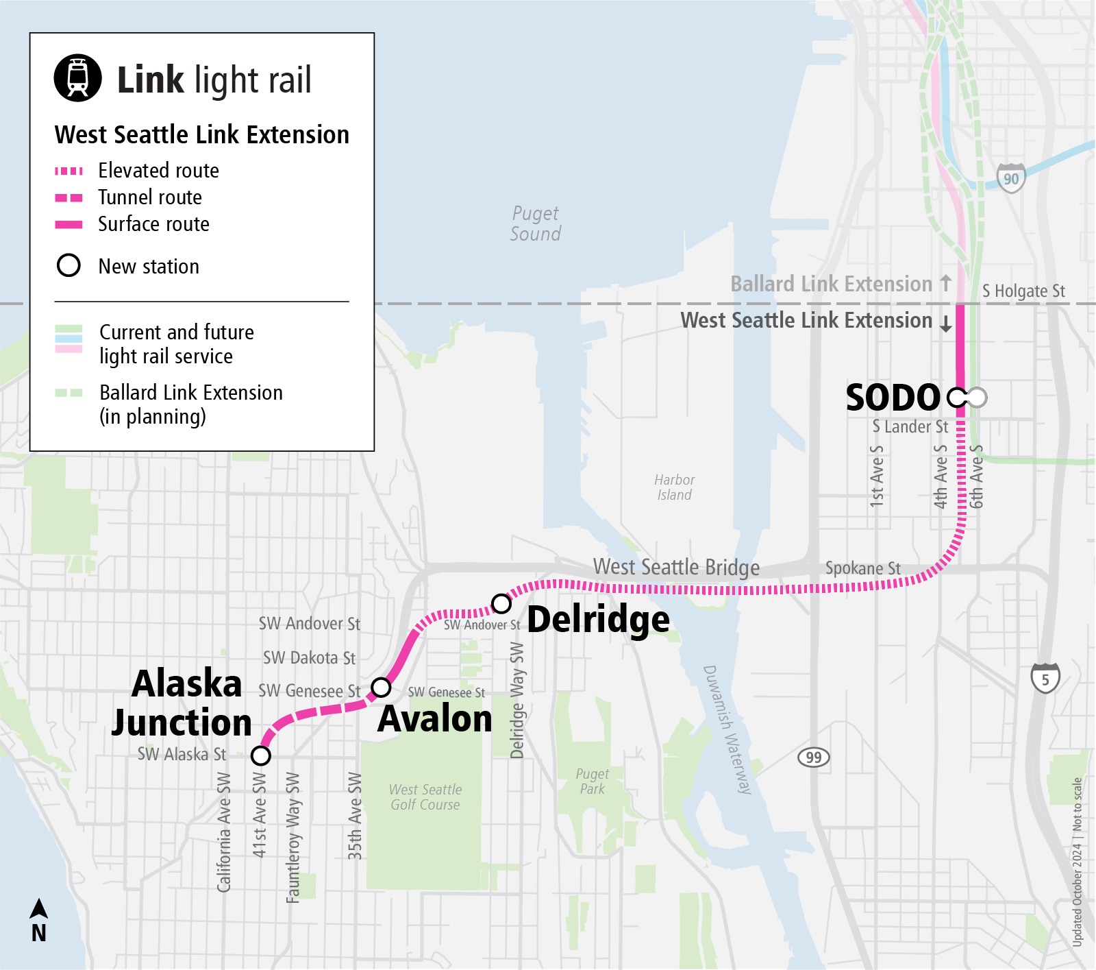
West Seattle Link Extension project map
WSLE Final EIS
The West Seattle Link Extension Final Environmental Impact Statement (EIS) is now available for review. The Final EIS includes updates based on continued design and comments received on the West Seattle and Ballard Link Extensions (WSBLE) Draft Environmental Impact Statement. The WSLE Final EIS also includes responses to substantive public, agency, and Tribal comments (project-wide comments and comments specific to WSLE) submitted during the Draft EIS comment period. Comments about Ballard Link Extension (BLE) will be responded to as part of the separate BLE environmental process.
Description of WSLE project to be built
The following dropdown sections describe the segments for the project to be built. For information on other alternatives previously studied, please refer to Chapter 2 of the Final EIS.
The West Seattle Link Extension will begin just north of the existing SODO Station and travel at-grade west of and parallel to the existing Link light rail line. It will continue south at-grade under South Lander Street, which will be reconstructed as an overpass over the new and existing light rail. It will transition to an elevated guideway south of South Lander Street.
The new SODO Station will be at-grade, immediately west of the existing SODO Station. The existing at-grade pedestrian crossing of the light rail tracks at SODO Station will be closed, and a new pedestrian grade-separated crossing of both existing and new tracks will be used to access both stations. There will be a station access from the new South Lander Street bridge. Access to 4th Avenue South will occur via South Lander Street.
Elevated route will continue along the west side of the existing light rail line, south from South Forest Street; continuing southwest to cross over to the south side of the Spokane Street Bridge and the West Seattle Bridge. The guideway will continue west and to the south side of the West Seattle Bridge, crossing over the Duwamish Waterway and Harbor Island on a new high-level fixed bridge. The height of the bridge could be adjusted through coordination with the United States Coast Guard. The guideway will then cross the northern edge of Pigeon Point in a combination of elevated guideway and retained cut-and-fill; turning southwest on an elevated structure that follows Delridge Way Southwest.
Elevated route will continue along the west side of Delridge Way Southwest, north of Southwest Andover Street. The elevated guideway will travel west along the north side of Southwest Yancy Street then cross Southwest Avalon Way, transitioning from elevated to at-grade in the vicinity of 32nd Avenue Southwest. The guideway will turn south to travel south along the east side of the West Seattle Bridge connection to Fauntleroy Way Southwest and transition into a retained cut.
The Delridge Station will be elevated north of Southwest Andover Street and west of Delridge Way Southwest in a northeast-southwest orientation.
Tunnel route will begin in a retained cut south of Southwest Yancy Street and follow the east side of the West Seattle Bridge/Fauntleroy Way Southwest to Southwest Genesee Street, entering into a tunnel at Southwest Genesee Street and 37th Avenue Southwest and curving southwest west of 37th Avenue Southwest to 41st Avenue Southwest to terminate at Southwest Hudson Street, with tail track in a north-south orientation under 41st Avenue Southwest.
The Avalon Station will be in a lidded retained cut south of Southwest Genesee Street, beneath 35th Avenue Southwest.
The Alaska Junction Station will be in a tunnel beneath 41st Avenue Southwest and Southwest Alaska Street. Station entrances will be on either side of Southwest Alaska Street. The entrance south of Southwest Alaska Street will be on the west side of 41st Avenue Southwest. The entrance north of Southwest Alaska Street will be on the east side of 41st Avenue Southwest.
November 2016: Sound Transit 3 voter approved
- Sound Transit 3 (ST3) is approved by voters. This plan includes adding 62 new miles of light rail, totaling more than 116 miles with over 80 stations added to the region. Part of this plan includes the West Seattle Link and Ballard Link Extensions (WSBLE) projects, other projects like the bus Rapid Transit (BRT) on the Eastside, additional capacity for the Sounder South line, and access improvements to stations for all modes of travel.
2017 – 2019: WSBLE Alternatives Development
- October 2017: West Seattle Link and Ballard Link Extensions project kicks off the planning phase of the project. The phase is part of the Federal Transit Administration’s (FTA) environmental review process.
- January 2018: Sound Transit hosts the first Stakeholder Advisory Group and Elected Leadership Group meetings to introduce the project and share what to expect for the alternatives development phase.
- February – March 2018: Sound Transit hosts early scoping open houses and a comment period to collect public feedback on the ST3 representative project and gather new ideas to inform development of additional route and station location alternatives.
- March 2018 – April 2019: Sound Transit develops and refines alternatives based on technical evaluations, as well as feedback from the public, Stakeholder Advisory Group, Elected Leadership Group, and Sound Transit Board of Directors. The project goes through three levels of evaluation between early scoping and scoping to help further refine alternatives.
- February – March 2019: Sound Transit hosts scoping open houses and a comment period to collect public feedback on the alternatives to date and topics to study in the Draft Environmental Impact Statement (EIS).
- May 2019: The Sound Transit Board reviews the alternatives, evaluation results, public feedback, and the recommendations of the Elected Leadership Group and identifies the preferred alternative and other alternatives to study in the WSBLE Draft EIS.
- May – October 2019: The Sound Transit Board directs staff to conduct initial assessments on additional route and station options that were suggested during the public scoping period, to establish whether further study in the WSBLE Draft EIS is appropriate.
2019 – 2023 WSBLE Draft Environmental Impact Statement
- May 2019 – December 2021: Sound Transit develops the WSBLE Draft EIS, a document that describes the multiple alternatives being considered, and how each alternative might affect the natural and built environment and transportation systems, both during construction and final operation of the light rail lines.
- November 2019 – January 2020: Sound Transit conducts extensive engagement efforts to gather public feedback regarding WSBLE Station Planning. Sound Transit hosts neighborhood forums and community briefings throughout the project corridor.
- November 2021 – May 2022: Sound Transit kicks off Community Advisory Groups to review and discuss WSBLE Draft EIS findings with community members throughout the corridor. Meetings are online and open to the public.
- January 2022 – April 2022: The Draft EIS is published for a 90-day public review and comment period. Comments are accepted via email, mail, voicemail, comment form, at a virtual public hearing, or an in-person open house. All the details can be found here. Sound Transit receives over 5000 comments. Additionally, in partnership with the City of Seattle and King County, Sound Transit publishes the WSBLE Station Planning Progress Report alongside the WSBLE Draft EIS to help communities understand the opportunities and challenges of the different alternatives.
- July 2022: After reviewing the Draft EIS and the comments from Tribes, the public and agency partners, the Sound Transit Board identifies the preferred alternative for the West Seattle Link Extension (WSLE) and requested further studies for the Ballard Link Extension (BLE). Read the July 2022 Board Motion and press release for more information.
- August 2022 – March 2023: Sound Transit conducts further studies that included six workshops and open houses and three online surveys for WSBLE. For an overview of the further studies conducted for both extensions and the results, read the Further Studies Executive Summary and reports.
- March and July 2023: The Sound Transit Board identifies a preferred alternative for the BLE. Refinements to WSLE alternatives from the further studies are being incorporated into the WSLE Final EIS. Read the March Board Motion, July Board Motion, and press release for more information.
- September 2023: Given additional environmental review needed for project refinements for BLE resulting from the Sound Transit Board action in March 2023, environmental review for the WSLE and BLE projects proceed on different timelines.
2023 - 2024: West Seattle Link Extension (WSLE)’s Final Environmental Impact Statement
- Fall 2023 to Spring 2024: Sound Transit and the City of Seattle jointly engaged in WSLE station planning events to gain feedback and update travel patterns and community priorities by hosting community briefings, online survey, drop-in, in-language focus groups, and open houses in the neighborhood, and published the WSLE Station and Access Planning Engagement Report.
- September 2024: Sound Transit published the WSLE Final EIS.
- October 2024: The Sound Transit Board selected the route and station locations for the West Seattle Link Extension.
WSLE Final EIS
An Environmental Impact Statement (EIS) provides Tribes, agencies, and the public an understanding of a project’s potential impacts and benefits of each alternative by describing how the alternative might affect the natural environment, built environment, and transportation system. The Final EIS identifies ways to mitigate impacts. Through this process, we analyze each alternative and design option, considering effects on historic and cultural resources, residential properties, businesses, communities, the local economy, and other resources.
In September, the Federal Transit Administration and Sound Transit published the WSLE Final EIS. The Final EIS includes updates based on continued design and comments received on the West Seattle and Ballard Link Extensions (WSBLE) Draft EIS. The WSLE Final EIS also includes responses to substantive public, agency, and Tribal comments (project-wide comments and comments specific to WSLE) submitted during the Draft EIS comment period. Comments about Ballard Link Extension (BLE) will be responded to as part of the separate BLE environmental process.
On Oct. 24, 2024, the Board selected the preferred alternative as the project to be built for WSLE, a step to completing the environmental review phase and allowing the project to proceed into design. This decision includes the light rail route, profile, and station locations for WSLE as the project advances into the final design phase and was based on years of technical analysis and community feedback through our study of multiple routes and station alternatives since 2017.
We anticipate the Federal Transit Administration to issue a Record of Decision in early 2025 under the National Environmental Policy Act. With that, the project will begin final design as well as develop and implement a workplan to improve the agency’s financial situation and move WSLE through design to inform a financially sound project to be baselined.
Review the Final EIS online
The Executive Summary provides an overview, summarizing elements of the larger Final EIS to help readers quickly become acquainted with the project.
- WSLE Final EIS Executive Summary - English
- WSLE Final EIS Executive Summary - Spanish
- WSLE Final EIS Executive Summary - Simplified Chinese
- WSLE Final EIS Executive Summary - Traditional Chinese
- WSLE Final EIS Executive Summary - Vietnamese
You can view the entire Final EIS online.
To request a printed copy or a thumb drive of the Final EIS or Executive Summary, contact Dominique Jones at dominique.jones@soundtransit.org.
- Seattle Public Libraries:
- Beacon Hill Branch, 2821 Beacon Avenue South, Seattle, WA 98144
- Central Library, 1000 4th Avenue, Seattle, WA 98014
- Columbia City Branch, 4721 Rainier Avenue South, Seattle, WA 98118
- Delridge Branch, 5423 Delridge Way Southwest, Seattle, WA 98016
- High Point Branch, 3411 Southwest Raymond Street, Seattle, WA 98126
- International District Branch, 713 8th Avenue South, Seattle WA 98104
- New Holly Branch, 7058 32nd Avenue South, Seattle, WA 98118
- Rainier Beach Branch, 9125 Rainier Avenue South, Seattle, WA 98118
- West Seattle Branch, 2306 42nd Avenue Southwest, Seattle, WA 98116
- University of Washington-Suzzallo Libraries, 4000 15th Avenue Northeast, Seattle, WA 98195
- King County Library System:
- Burien Library, 400 Southwest 152nd Street, Burien, WA 98166
- White Center Library, 1409 Southwest 107th Street, Seattle, WA 98146

.png)